Public Notice – Update on 417 Industrial Park
Municipal Class Environmental Assessment Study
Road Network Expansion, 417 Industrial Park, Township of Russell
Public Notice – Update
Date: November 14th, 2024
Project Overview
The Corporation of the Township of Russell has progressed with a Schedule B Class Environmental Assessment (Class EA) to review and study the proposed expansion of the road network within the 417 Industrial Park. The road network expansion intends to provide access to subject lands, optimize new lot configuration by providing frontage for future site developments, and improve transportation efficiency to and within the park, all while considering existing conditions and constraints.
This project is being carried out in accordance with the requirements of the Municipal Class EA, following a clear, phased planning process with public and stakeholder engagement.
Project Status Update
The Municipality is committed to an inclusive approach that incorporates public feedback and ensures environmental and community considerations are prioritized. A Public Information Centre was held on May 30th, 2024 where alignment options were presented to the public for feedback. There has been significant progress in addressing public input and advancing studies that are central to the project. Key updates include:
1. Consideration of Public Feedback
Feedback from public consultations and community input has been carefully reviewed and integrated into the EA process. Public concerns regarding traffic impacts, environmental sensitivity, and overall community well-being have been instrumental in refining the study scope and identifying specific areas requiring further assessment.
2. Further Environmental Investigations
In response to environmental concerns raised by residents and stakeholders, additional review of available documentation has been completed. An Environmental Assessment Study and Natural Environment Assessment Report for the subject land was reviewed to screen for potential sensitive environmental features such as significant woodlands, unevaluated wetlands, and identified ecological land classifications. Findings from the referenced report do not identify any ecological constraints in the proposed roadway alignment location.
3. Traffic Study Initiation
To ensure traffic management aligns with community needs and end users within the 417 Industrial Park, a comprehensive traffic study is being conducted for the intersections impacted by the selected road network alignments. This study aims to evaluate current and projected traffic
patterns, assess the impact of potential roadway expansion to the overall Industrial Park, and identify improvements that enhance safety and reduce congestion. Data from the traffic study will help optimize roadway design and provide recommendations on intersections, and any other vehicular accommodations.
4. Revised Roadway Layout Configuration
Based on public feedback and further analysis, the technical, socio economic, environmental, cost and constructability aspects have been further reviewed for the previously presented options.
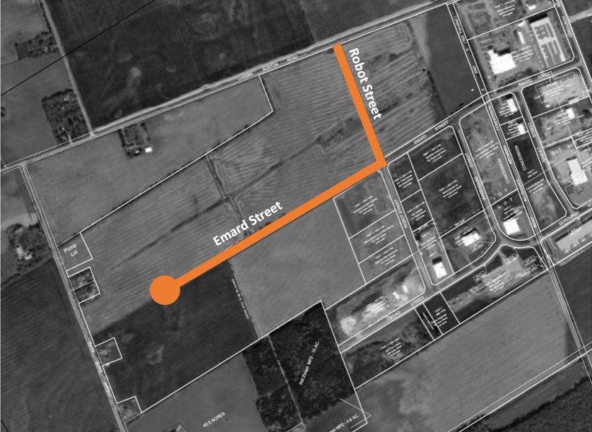
Rationale specifically related to the impact on the surrounding properties and internal park connectivity have impacted the evaluation of the potential alternatives for the alignment of the roadways. The updated preferred option proposes terminating the roadway extension of Emard Street with a cul-de-sac prior to reaching Eadie Road. This configuration will meet minimum requirements for emergency vehicle access as per NFPA (National Fire Protection Association) Standards and consider efficient snow removal practices for improved winter accessibility. Additionally, the cross-section design will reflect a rural cross-section with roadside ditches to manage stormwater and maintain a natural setting.
Access into the Industrial Park from Burton Road will extend between Emard Street and Burton Road aligned with the current right of way of Robot Street. Figure 1 below provides a Sketch of this alignment.

Figure 1: Cul-de-sac at Emard Street and Extension of Robot Street
(Presented as Option 3 at the Public Information Centre in May 2024)
Additional considerations in the detailed design of the roadways include:
- The Wood Eadie Municipal Drain, which intersects the roadway alignment, has undergone an update to the Engineer’s Report under section 78 of the Drainage Act, detailing what the culvert crossing details would be in the drain profile to ensure there will be no negative impacts to the natural features or ecological functions within the area surrounding the proposed Right-of-way.
- Optimization of Roadway Profiles to support the Ontario Regulation 406/19 and improve management of excess construction soil.
- Appropriately design sediment and erosion control measures in place during construction to mitigate risk to downstream waterways/Municipal Drain.
5. Archaeological Assessment
A Stage 1 Archaeological Assessment has been completed, and it was determined that the study area exhibits potential for the presence of archaeological resources. A Stage 2 Archaeological Assessment is now underway.
Next Steps
The Municipality will continue with the Environmental Impact Study and Traffic Study, and results will be made available to the public as they become available. Public engagement remains a priority, and we will continue to provide opportunities for feedback as the studies progress.
Contact Information
We appreciate the community’s feedback If you have any questions, concerns, or require additional information, please contact:
Francois Landry
Project Manager
Russell Township
613-443-1747
francoislandry@russell.ca
Kyle Herold
Civil Engineering Designer
LRL Engineering
613-842-3434
kherold@lrl.ca
Thank you for your continued participation and engagement in this process
